South Murwillumbah Matters
LONG READ
AN ENVIRONMENTAL HISTORY
Written by Dr Johanna Kijas
An introduction
For many of us living near the major rivers of New South Wales’ Far North Coast, recent extreme flooding has been foremost among the natural hazards we’ve encountered. Increasingly, community and government focus on climate emergencies are turning to long-term, knowledge-driven preparation rather than just recovery and repair. This means grappling with the interwoven histories of people and place – our environmental histories where the weather, water, place and people are entirely entangled – to help us build a safer and robust future.
This essay looks to South Murwillumbah in the Tweed River flood basin. The February 2022 ‘flood of record’ that followed the devastation of March 2017 flooding brought higher, faster and more dangerous flood conditions to the historically flood-prone community than ever before. Voluntary home buybacks begun by the local council in previous years were dramatically escalated under the NSW Reconstruction Authority’s Home Buyback scheme. As South Murwillumbah transitions with the house removals, this story journeys from the banks of the Tweed River to the broad climatic patterns that historically have driven our wet and dry times along Australia’s eastern seaboard and back to local streets.
It has always flooded on the Tweed. However, post-colonial land use, government and community understandings of flooding, and flood memory has varied over generations. European settlement of Murwillumbah’s South Side expanded through the early decades of the twentieth century and again from the 1980s, coinciding with long-term weather patterns that brought fewer extreme floods. Flood memory receded. Taking an historical lens to flood preparation that includes both the local focus onto the riverbank, and broader climatic patterns, is one significant element in understanding how we plan for climate emergencies into the future.
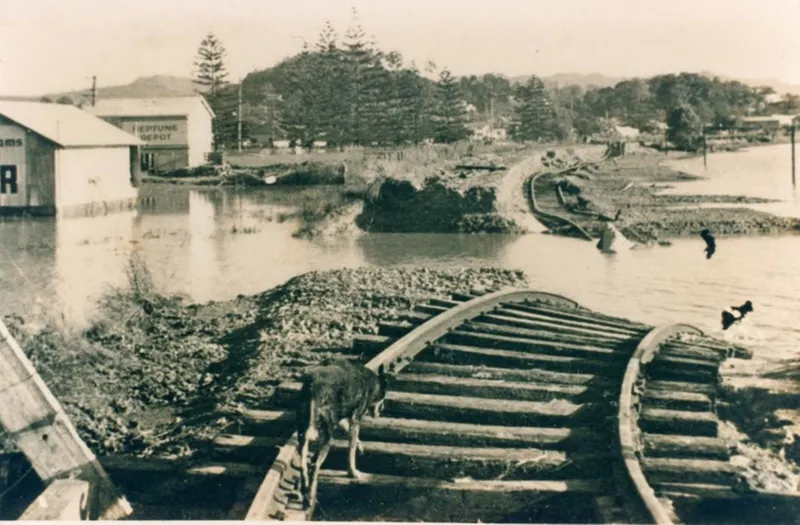
Moderate flooding in South Murwillumbah in 1916. David Holston and Holston Family Collection.
‘South Murwillumbah Matters’
In 1916 the Tweed Daily newspaper renamed its regular column about the South Side, ‘South Murwillumbah Matters’. Domestic matters were noted, such as a new shop in Prospero Street or pigs being herded along Bray Street (now Tweed Valley Way) to the railway station. Matters that drew the main town’s attention to their neglected southern neighbours were also raised such as their lack of electricity, unpaved streets and the undrained swamps.
The Tweed River was ever present, as a barrier to be crossed, pleasant Sunday boating, a decent haul of fish and floods. Flood waters had thundered through Murwillumbah’s early streets and buildings of the late 1800s, but the dry conditions of the early 1900s provided a more benign flow of water - on the main town’s side. Even then, however, South Murwillumbah regularly had flood water in it.
While slow to develop as an urban hub, South Murwillumbah was expanding by 1916 as can be seen in the image above. Houses had spread along the riverbank and in this flood, most can be seen to stand clear of the floodwaters, although surrounded. Water filled the swales along River Street and behind Wardrop Street, leaving the train high and dry on its tracks. Two years later the home of John and Ann Holston was completed on the banks of the Tweed River at 93 River Street.
John Magnus Holston was ‘first to open in business in Prospero Street’, moving his furniture emporium from Main Street in Murwillumbah to the South Side in 1901. He had a flat built in the first of what would become a number of buildings belonging to the enterprise. Having lived there for nearly 18 years, at last the family moved to their newly completed home in 1918. The Tweed Daily reported that it was ‘probably the most ornate and up-to-date in town, if not on the whole river. The site is one of the picked blocks in South Murwillumbah and has a wide frontage to a fine stretch of the riverbank.’

The Holston’s newly built home on the banks of the Tweed River called Zenobia, after the sailing ship/barque on which John had travelled to Australia from Norway aged 19. Image courtesy of David Holston and Holston Family Collection.
No doubt the Holstons would have heard of the last major flood of 1893. And as South Murwillumbah regularly had low to mid-level floodwater in it throughout the early twentieth century, they would reasonably have had a good sense of the flow of the river. We can assume that they built Zenobia on the natural levee bank believing it was a safe and lovely place to establish the family home.
And yet today the bank is clear of all those houses from the photograph. One can place the site of the house in front of the little park of trees on River Street called Holston Park. The bank was heavily eroded in the 2017 floods but repaired. In February 2022 the house suffered catastrophic damage to its up-river side and great logs were thrown up onto the bank. Zenobia was part of the Tweed Shire Council buyback scheme and demolished. What had happened over the previous one hundred years to come to this?

Tweed River catchment map. Map courtesy of NSW Environmental Protection Authority.
Two dominant features have shaped the Tweed Valley – Wollumbin/ Mount Warning and the Tweed River system. The many tributaries of the Tweed River begin in the caldera of the Tweed Shield Volcano. The caldera is the hollow that formed when the massive volcano collapsed after a series of eruptions over 20 million years ago. Mount Warning at its centre, from a geological viewpoint, is the central plug which is the hardest and last part of the volcano to erode, surrounded by its ring of mountain ranges.v
The fast-running streams that cascade off the steep sides join to form the three arms of the Tweed system. These are the Rous River or North Arm meeting the main river at Tumbulgum; the Oxley River, Mid or Central Arm that joins the main Tweed River, or the South Arm, just above Murwillumbah at Byangum. This is the system in flood that particularly impacts South Murwillumbah.
The Tweed starts to meander below Byangum near Bray Park. It continues across the flood plain before flowing out to sea at Tweed Heads. ‘Active meandering’ is part of the Tweed’s natural habit across the open valley. Previously reaching Byangum, today the tidal/salt limit reaches the Bray Park Weir, topping it occasionally into Murwillumbah’s drinking water.
The Tweed River: From its source to the sea
Any tracing of riverbank history starts at its source. It is a meandering journey. Meander is a geographical term referring to what rivers naturally do once they start to enter the flood plain, created through the millennial process of floods bringing silt that build the banks and erosion that carves them away.
Two dominant features have shaped the Tweed Valley – Wollumbin/ Mount Warning and the Tweed River system. The many tributaries of the Tweed River begin in the caldera of the Tweed Shield Volcano. The caldera is the hollow that formed when the massive volcano collapsed after a series of eruptions over 20 million years ago. Mount Warning at its centre, from a geological viewpoint, is the central plug which is the hardest and last part of the volcano to erode, surrounded by its ring of mountain ranges.
The fast-running streams that cascade off the steep sides join to form the three arms of the Tweed system. These are the Rous River or North Arm meeting the main river at Tumbulgum; the Oxley River, Mid or Central Arm that joins the main Tweed River, or the South Arm, just above Murwillumbah at Byangum. This is the system in flood that particularly impacts South Murwillumbah.
The Tweed starts to meander below Byangum near Bray Park. It continues meandering across the flood plain before flowing out to sea at Tweed Heads. ‘Active meandering’ is part of the Tweed’s natural habit across the open valley. Previously reaching Byangum, today the tidal/salt limit reaches the Bray Park Weir, topping it occasionally into Murwillumbah’s drinking water.
The catchment area of c.1,326 square metres means it is the smallest of the Northern Rivers catchments. Neighbouring Richmond River catchment, for example, is about 7,000 square kilometres. The ‘runoff response time’, where water travels over the land surface rather than being absorbed into the soil, is the fastest of all the North Coast rivers.

The Tweed River looking south to Wollumbin/Mt Warning from Bray Park c.1910.
Image courtesy of Tweed Regional Museum.

The Tweed River meandering north from Byangum towards Murwillumbah c.1920.
Image courtesy of Tweed Regional Museum.
The thick, dark rainforests of the Tweed Caldera started to establish after volcanic activity ceased 20 million years ago. Botanist Alex Floyd noted that lowland sub-tropical rainforest spread across the entire flood plain, through to European arrival, interspersed with swamps. The drier forest and coastal heath stabilised from about ten million years ago. The Tweed Valley is particularly rich in plant and animal life because it is where northern tropical and southern temperate species overlap at their respective geographical reaches.
This was the ancestral home of Tweed Bundjalung people for at least 20,000 years in archeological time, refining their stories and their skills to living in this highly diverse land and waterscape.

Tweed Bundjalung people: The original custodians
Tweed Bundjalung people and their visitors travelled across their country on the more sparsely covered ridges. They drank from the springs rather than the river water, usually camping beyond its banks due to flooding and above the mosquito and snakey, but very resource-rich swamps.
In 2018 Tweed Bundjalung people collaborated to write the following:
The language dialect for the Tweed is known as Ngandowal, a name referring to the people who say ‘Ngando’ for the word ‘who or ‘somebody’… There is general acceptance among our Tweed Aboriginal community of the presence of three main groups in the Tweed River Valley.
These are the Goodjinburra people for the Tweed Coastal area, the Tul-gin-gin people of the North Arm, and the Moorang-Moobar people from the Southern and Central Arms around Wollumbin (Mt Warning). However, European settlers used other names and described them as Chubboburri, Gandowal, Duthurinbar, Wirangiroh, Wollumbin, Murwillumbah, Ngarrumbul, Kitabul, and Ngarartbul. These names largely reflected a lack of understanding of our culture, our language and our connection to each other.
Research suggests that prior to any European contact each of the three groups may have contained between 500 and 700 members, distributed in smaller family groups across what was then their area of ‘country’. With a loss of access to food resources, death from illness and disease, and intolerance shown by some European settlers, population numbers plummeted and were only about 10% of original numbers within 60 years.
Clearing, erosion and draining the swamps
Environmental change to the Tweed Valley came later in the nineteenth century than its neighbouring river catchments but was just as far reaching.
In 1914 the South Murwillumbah correspondent for the Tweed Daily noted:
I was glad to see some reference made in your Saturday’s issue to reafforestation. It is a matter that warrants serious attention. We are cutting out millions of feet [of timber] a year and very little attempt made to provide for future requirement after our forests are devastated.
He pointed to lessons he felt should have been learned following the ‘wholesale destruction’ of the neighbouring Dorrigo Plateau forests in the 1890s.
Overwhelmingly, however, there was a sense of exuberance for the civilising of the landscape for dairying and cane farming, and the belief that an abundance of timber was available into the future. As settlement continued at speed across the Valley to the 1920s, there was some clear evidence of consequences. Forest clearance of the riverbanks and in the upper estuary, plus swamp drainage across the flood plain, meant faster runoff into the river system, higher flood peaks and increased susceptibility to erosion of the riverbanks.
The Salome north of Murwillumbah near Byangum c.1899. Tweed Regional Museum.
One early consequence noted often in the newspapers was the build-up of silt in the river. In 1913 the Sydney Morning Herald reported of the Tweed that: ‘Since the recent fresh in the river … it has considerably silted up, and ocean-going steamers are experiencing difficulty in reaching Murwillumbah.’ Regional and state conferences were held to discuss bank erosion. Mostly participants blamed the larger riverboats for travelling too fast and sending waves into the banks causing the erosion. But a lone voice at the 1908 Wardell conference, Councillor McKinnon, suggested that clearance of timber from the banks was another factor.
Improved road infrastructure was already impacting the passenger steamer trade by 1930. By the late 1930s steamers carrying cargo for the North Coast Steam Navigation Company could no longer reach Murwillumbah.
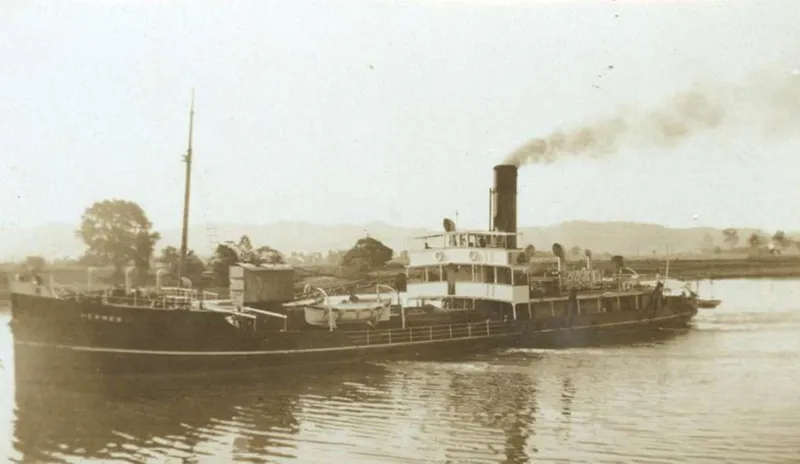
The Hermes on the Tweed River in the 1930s. Image courtesy of Tweed Regional Museum.
From slow beginnings to a bustling centre: South Murwillumbah
The buildup of silt was a natural process of the flood-prone Tweed River, indicated by the levee bank on which the Holstons’ house Zenobia was built. By 1918 both sides of the river were full of houses, but the first surveyor of Murwillumbah had avoided the river. Initially surveyed in December 1868, Murwillumbah was finally gazetted as a village 11 years later in 1879 when riverfront land was included into its redesign. (Lismore was surveyed in 1855 and gazetted as a village one year later).
In 1893 488 allotments were auctioned in the new town of ‘South Murwillumbah’ called Doughtery’s subdivision. However, it was only once the railway arrived in December 1894 that some allotments began to sell. The ferry was replaced by the bridge off Prospero Street in 1901. It took until 1916/17 for ‘a mild building boom’ to be reported by the Tweed Daily.

Dougherty’s subdivision map of South Murwillumbah 1893. Tweed Regional Museum.
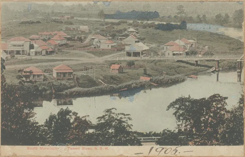
South Murwillumbah 1905. Holston’s Furniture Emporium can be seen on Prospero Street in front of the bridge. Image courtesy of Tweed Regional Museum.
While urban development was a bit sluggish, commercial development in Prospero Street picked up speed once the bridge was built. After establishing his furniture business for a year in Main Street, John Holston bought land in 1901 in Prospero Street, opening in 1902. He would expand on both sides of the original structure plus building a furniture factory behind the emporium. John was also an undertaker, running his funeral business in the premises. His oldest son Len Holston took over as Funeral Director when his father drowned in 1928.
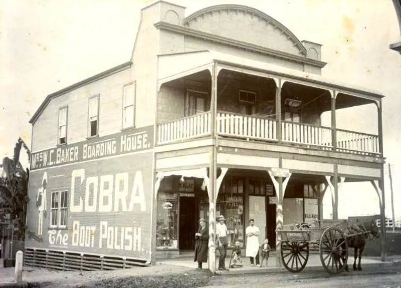
Mrs Baker’s boarding house in Prospero Street early 1900s. Image courtesy of Tweed Regional Museum.

The first of Mr J. M. Holston’s Furniture Emporium buildings at 19 Prospero Street c.1910. Image courtesy of Tweed Regional Museum.
More businesses followed the devastating September 1907 fire across the river, where nearly every building in Main Street and most of the business district was destroyed. H. E. Hartmann established his grocery store in 1910 and had the premises rebuilt in brick in 1933. ‘You can get groceries, draperies, fancy goods, all manner of goods... and household luxuries can be had’ the Tweed Daily gushed.
When the grocery business vacated, the building fell into some disrepair. Geoff Smith bought the building and started his panel beating business in 1968, the year the new bridge was completed (now owned by son Murray).
Prospero Street linked the Tweed River at one end to the train station at the other. The rail link to the deep seaport at Byron Bay, and eventually via Casino to Sydney, was a key economic driver for the region.
Produce from the South Side dairy factories of NORCO and the Tweed River Co-op, and later the Banana Growers Federation factory, employed large numbers and sent their produce south on the train. The station was a daily hub of activity with passengers and cargo.
At least until the mid-twentieth century everything you needed was available in South Murwillumbah. Butchers, bakers, barbers and a bike shop, chemist, doctor, post office, billiards room, café, car dealerships, and garage, plus the Regent Theatre on Alma Street before it burnt down and two hotels. It was a bustling urban, commercial and industrial part of Murwillumbah.
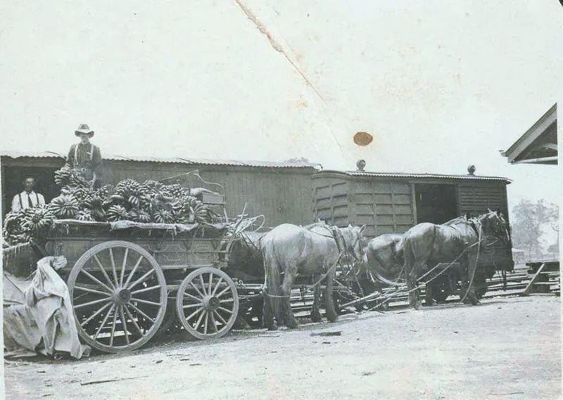
Two ‘banana trains’ left South Murwillumbah each week, sometimes carrying 44,000 cases bound for Sydney. Here men load bananas onto the train cars c.1910. Image courtesy of Tweed Regional Museum.
Floody South Side
And there was something that bound all these South Side dwellers together – floods. They were largely a manageable part of life in the first fifty years of settlement, but no less frustrating. ‘Southside still underwater,’ was reported in May 1906. The first decade of the twentieth century was a dry to drought time across the eastern seaboard, including the Far North Coast, and this mild event rates no mention in most Tweed Valley flood recordings. But for South Murwillumbah it was water and mud as usual.
There had been a period of major floods throughout the late 1800s. ‘The greatest flood ever known on the Tweed River’ was reported in April 1887. ‘So sudden was the flood that people had no time to save anything.’ The next destructive one thundered through in 1893.
Then, only two major floods followed over the next 51 years. ‘Nuisance floods’ still regularly reached Southside streets, and the second decade of the twentieth century was quite wet. There were moderate floods in 1916 and 1919. Then came the major flood of July 1921. ‘Tweed River swamps Murwillumbah’ the headlines rang out. ‘It was the greatest shock the residents had ever experienced… The river swelled with sensational rapidity and by 10 o’clock [pm] the water was breast deep in South Murwillumbah streets.’
A flood gauge was installed in 1928. Southside was again ‘invaded’ in February 1931, and council subsequently built two flood boats. ‘The trouble was’, the Tweed Daily noted, by the next major flood in 1945 ‘no one knew where they were.’
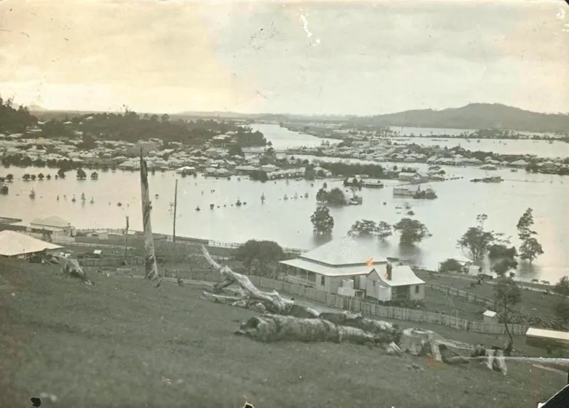
Looking across to South Murwillumbah in the 1921 flood. Image courtesy of Tweed Regional Museum.
A deputation of South Side residents to Council ‘painted a graphic picture of the appalling living conditions which follow in the wake of frequent floods which inundate low-lying land of South Murwillumbah.’ On the other side of the river, after the 1931 floods, the Lavender Creek floodgates were installed to protect Murwillumbah from minor and moderate flooding.
But in the following 14 years when the north side only experienced one flood (1945), South Murwillumbah experienced, according to the newspaper, 14 or 15 floods. Council was told that South Side residents didn’t mind an increase to their rates ‘so long as some definite improvement resulted.’However, the 1945 flood was just the start of decades of renewed major flooding.
Back-to-back La Niñas: 1950s to 1970s
From 1945 the long-term weather pattern shifted away from the first half of the twentieth century’s drier times. Meteorologists refer to a ‘climate shift’ as a long-term, persistent change in the average weather pattern of a region that lasts decades, rather than temporary, year-to-year variations. Many will have direct memories, or family stories, of those thirty plus years of downpour and extreme flooding.
By the time major flooding began again from 1945, the Tweed Valley was a very different social and economic landscape. Urban, agricultural and industrial development had pushed further onto the floodplain, where land use was more extensive and intensive. Walkabout magazine featured a six-page article on the Tweed River Valley in November 1949. Brimming with enthusiasm for lush farmland and scenic mountains, it concluded: ‘And yet, with all its prosperity, its rich fertility… there is an ever recurring question… “Will the river flood this year?”’ Only once the river was ‘tamed and checked’, it argued, could the Valley become ‘Fifty Miles of Paradise.’
The big floods of 1949 and 1950 on the Tweed were less severe compared to the utter devastation further down the coast, particularly Kempsey and Macksville. But the countryside was saturated. No one escaped the cyclone that turned back on itself through February 1954 causing record flooding across Murwillumbah, and across huge swathes of east coast Australia. Hardly time to clean up, two more major floods smashed through in 1955 and 56.
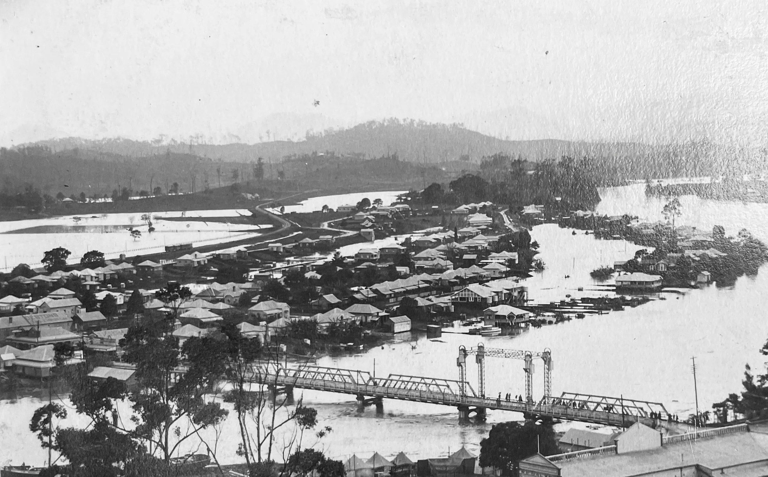
1954 flood destruction on the South Side. Flood water pouring down Prospero Street. Image courtesy of Tweed Regional Museum.
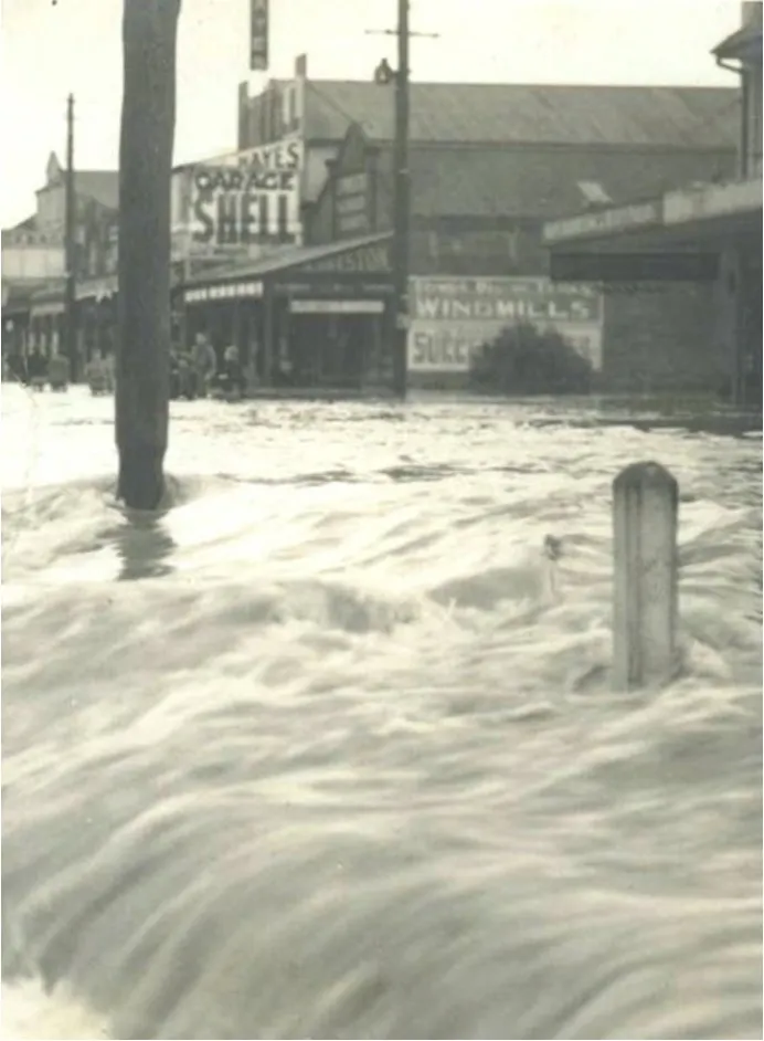
1954 flood destruction on the South Side. Flood water pouring down Prospero Street. Image courtesy of Tweed Regional Museum.
Flooding was so widespread and destructive that the NSW government formed the NSW State Emergency Service (SES) in April 1955, first called the Civil Defence Service. Government also began funding widespread structural flood mitigation work; levees, floodgates and swamp drainage etc. The first Commercial Road and South Murwillumbah earth levees were built under the Flood Mitigation Program 1963-1969.
Significant flooding into South Murwillumbah continued throughout the 1960s. Then of course another cyclonic system crossing the coast near Tweed Heads caused major flooding across Murwillumbah in March 1974, on the back of January flooding. Three decades of major flooding had created practiced flood communities.
The new post 1970s raft of flood planning research and reports made a shift from the 1950s flood reports that had established the array of engineering, structural flood mitigation works. The 1980 Tweed Valley floodplain management report’s key recommendations were ‘non-structural measures which will redirect development within the Tweed Basin floodplains so that future flooding will not cause the damage and inconvenience that has occurred in the past.’
The first two objectives were to 1. Prevent further development in the floodplain and the gradual clearing of existing development from such areas and 2. Flood immune construction of any further development … but only where this could be justified economically. ‘Structural works’ it argued ‘have a limited life in comparison to the life of a community so that eventually the only option is to restructure the pattern of community development within the basin.’
The Tweed River Flood Mitigation Committee was subsequently established in December 1982, with flood planning begun for Murwillumbah in 1984. The final plan of 1989 was a mix of structural mitigation strategies, regulation and calls for flood education. It noted that:
The Management Plan finally developed by the Committee provides an economically attractive scheme to increase the level of protection of Murwillumbah by leveeing. The potential damage to residents in South Murwillumbah and Bray Park is reduced by the introduction of a house raising scheme that ensures that no residents are adversely affected. A small increase in height of the South Murwillumbah levee should significantly benefit the Commercial area.
The Commercial Road levee was subsequently rebuilt in concrete. Point three of 16 points noted that in South Murwillumbah ‘the voluntary purchase scheme be continued to permit long term acquisition of high hazard riverfront properties in River Street, between Greville and Colins Streets.’ Increased flood warning was considered an essential component of the plan regarding potential complacency of those living behind the higher levees, thinking they would be protected from all floods.
Mitchell Tulau, ‘Lands of the richest character: agricultural drainage of backswamp wetlands on the North Coast of New South Wales, Australia; development, conservation and policy change: an environmental history’, Southern Cross University, 2011.
New shifts: 1980s to 2017
While flood planning was ongoing, another ‘climate shift’ followed the last of the big floods in March 1978. This was a return to three decades of relatively benign, dry to drought weather. There were major floods impacting both sides of the river in 1987 and 1989, and South Murwillumbah continued with low to mid-level floods in the early 2000s. But these were predominantly years of El Niño drought and devastating fires.
There was another shift in these drier decades. The climate shift coincided with what demographers have called the ‘population shift’ to the Far North Coast. The population of the Tweed Valley tripled from the 1971 census to the census of 2016. Flood history is not the first thing that is promoted to newcomers. Two to three generations who arrived in this era, calling the Tweed Valley home, had little or no flood memory and experience of major flooding.
However, no one had experienced what was to come. Murwillumbah’s flood of record in 2017, as is so well known, beat the previous disaster of 1954. And then 2022 went higher. On top of the historical, natural weather patterns bringing eras of flooding, the SES notes that ‘Climate change is expected to bring heavier rainfall and higher sea levels, which will make flooding worse in South Murwillumbah and nearby areas.’
Returning to the Riverbank
A series of transitions can be seen and imagined in the two photographs above. In the top one of the Holston house around 1918, one can imagine the transition from the low-land subtropical forest to the European urban development of South Murwillumbah. In the second one where Zenobia and the other houses have been removed from the bank, a more recent retreat from hazard has created further transition.
Historian Adele Wessell notes, however: ‘Our climate future requires not just the retreat from vulnerable areas, but the preservation of place-based knowledge that gives communities their strength and adaptability in the first place.'
The local SES, Murwillumbah Core born out of February 2022, and other community groups are actively working towards permanent preparation for whatever climate emergencies are in store, street by street. ‘It Takes A Town’ is asking us to imagine the type of Northern Rivers we want to live in, into the future. How do we make sure that there is genuine intermeshing between local knowledge and broader policy engagement.
Since the flood boats went missing in between the major floods of 1931 and 1945, there have been a myriad of local, state and federal responses to floods across our region. Following the devastation of the 1950s floods, government turned to structural solutions across the floodplain. Post the 1970s floods there was a shift towards regulation as well as engineering, to try and stop people and development being in harm’s way. The ‘climate shift’ towards drier times that then coincided with the ‘population shift’ of the 1980s, 90s and into the 2000s, however, left more recent arrivals of up to 30 years without the preparation and experience of regular, major flooding. When the floods of 2017 and 2022 hit, no one had past experience of the extremes of those events. However, climate change science suggests we need to be permanently prepared for what is to come.