Meeting of the waters: An environmental history of Coraki
LONG READ
AN ENVIRONMENTAL HISTORY
Written by Adele Wessel
An introduction
Coraki is shaped by the meeting of waters, ecologies and people. Positioned at the confluence of the Richmond and Wilsons Rivers, the town grew where fertile floodplains and dense subtropical forests had sustained Bundjalung communities for millennia. For Bundjalung people, floods were part of a dynamic and living landscape, and the country's rhythms were sustained through cultural burning and intimate knowledge of seasonal change. European settlement, timber-getting and the expansion of agriculture transformed the landscape, reshaping patterns of use, altering ecological systems and redefining relationships with Country. Tracing these layered histories together reveals how Coraki's environment has continually been made and remade — through natural forces, human interventions and enduring cultural connections.
The evolving attempts to predict, mitigate and live with floods, fire and drought reveal a complex interplay between human intention and the ecology of the river system. Attention in this paper is directed to how people have responded, adapted to, and sometimes exacerbated, the forces of water scarcity, fire and flood — revealing a landscape shaped by both geography and human agency. That agency often emerged locally, building community resilience and knowledge.
The village of Coraki developed within a landscape long cared for and managed by Bundjalung custodians whose continuous connections to the Richmond River and its floodplains carried deep knowledge of seasonal change, waterways and Country. Colonial settlement introduced new institutions and industries, but residents relied heavily on local initiative to respond to environmental challenges and sustain community life. Residents contributed land, labour and funds to establish community services, organised collectively to campaign for government support and built cooperative institutions when state assistance was limited or slow.
That tradition runs unbroken to the present: from the Campbell Hospital opening in 1903 through a resident's bequest, to the community-run library of the 1970s, to the Mid Richmond Neighbourhood Centre's Hands and Hearts Project in 2023, coordinating community fundraising and labour to repair homes after flood. Together these efforts demonstrate a long tradition in Coraki of residents sharing knowledge, organising collectively and responding to the environment.


Locating Coraki
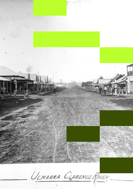
Coraki sits at the confluence of the Richmond and Wilsons Rivers, one flowing eastward from Casino and the other southward from Lismore. From this junction the river continues south for around eight kilometres to Bungawalbin Creek, before passing through Woodburn, Broadwater and Wardell, and entering the Pacific Ocean at Ballina. The name Coraki derives from the Bundjalung word Gurigay, meaning 'meeting of the waters' — a description that captures the town's physical geography and its deeper cultural significance.
Grace Roberts described the junction as a sacred place where spirits of the past linger. Writer Ruby Langford Gnibi, born at Box Ridge in 1934, expressed the abundance the river provided in her Ode to the Richmond River, speaking of shores surrounded by the Big Scrub, of food gathered along the banks at Bungwalbyn, Jackabulbyn, Minumi and Coraki.
The meeting of the waters also provided the foundation for a major river port and shipbuilding industry by the 1860s, dependent on the trees that grew in such abundance in the Big Scrub and the dry sclerophyll forests further south.
Representations of the river reflect culture, interests and values. In Bundjalung flood stories, Oliver Costello explains the creation of the Evans and Richmond Rivers through a battle between the Goanna, Dirawong and the Great Rainbow Snake as they chased each other through Country. Dirawong headland is a rainmaking site where, when Lore is not followed, the big rains and floods will come. Bundjalung notions of land encompass ongoing interrelationships between human and non-human entities, sustaining robust and resilient conditions for both. Country and waterways nourish and evoke custodial rights and obligations.
European colonists brought different ways of relating to non-human species and their habitats, understandings that shifted over time, but commonly privileged human utility. Rivers were imagined less as living systems than as resources for people, industry and agriculture. The Royal Commission on Water Conservation in 1893 described the Richmond as a 'great natural highway' through rich delta land, positioning the river primarily as a vehicle for commerce.
Colonial exploration of the region was propelled by environmental pressure as much as economic ambition. A three-year drought in southern districts during the 1820s, combined with a financial depression in Sydney, intensified demand for new pasture lands and drew attention northward.
Henry Rous, who named the river in 1828, described the banks as having the appearance of being often flooded, noting flat open forest, thick jungle, fine timber and rich alluvial soil.

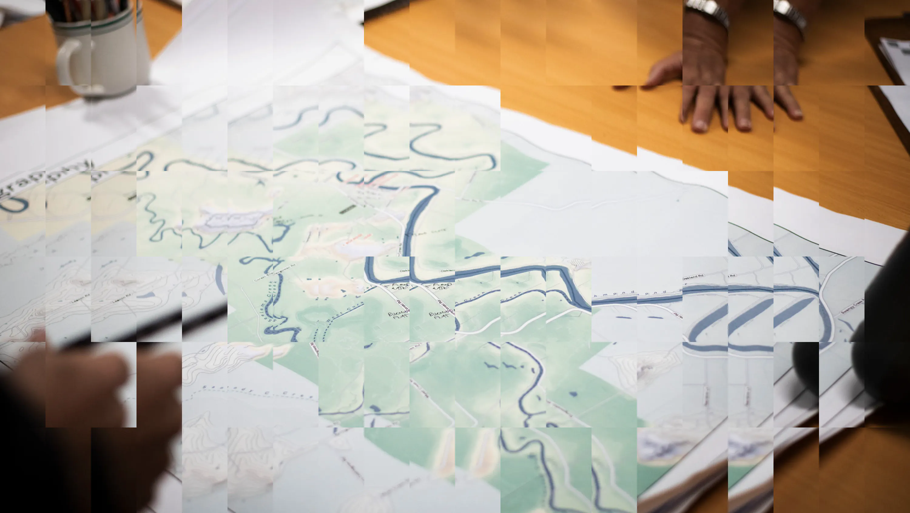
The floodplain map prepared by Sinclair Knight and Partners situates Coraki within the broader river catchment on the floodplain and illustrates the interconnected waterways that shape the landscape and history.

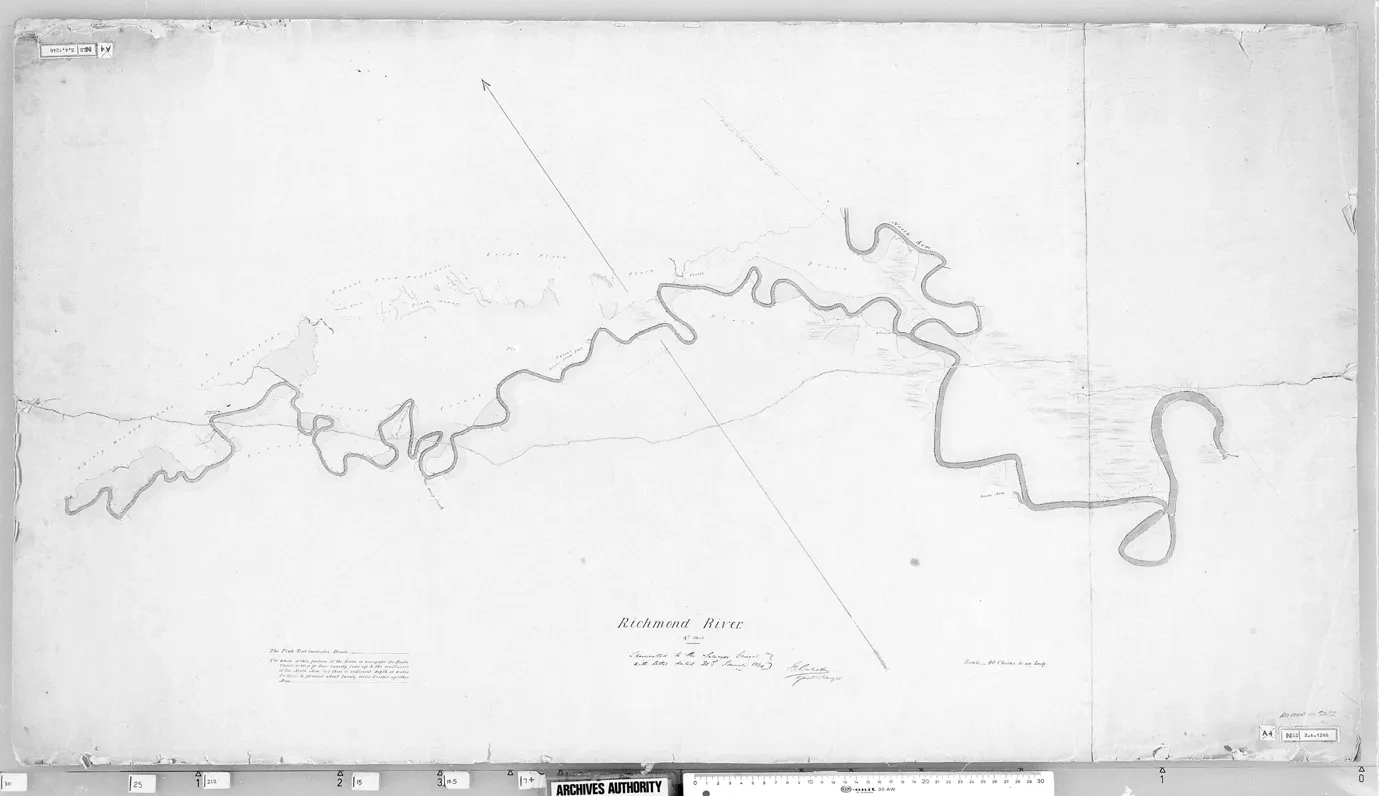
James Burnett (1844) Surveyor General’s Crown Plans 17921886, Map 5292. Museums of History State Archives Collection.


Trees, timber and transportation
The first squatters did not reach the Richmond Valley until 1840, but within five years all Crown land on the upper river was occupied. Cedar-getters arrived from the Clarence in 1842, drawn by the abundance of timber growing in the rich basalt soil and floodplain. By 1845 the Richmond was providing two-thirds of Australia's red cedar exports, cut first closest to the river. When James Burnett surveyed the river from its source to the coast in 1844 he already recorded a store at the junction of the rivers.
Brook Station was taken up in 1849 by William Yabsley, who had initially followed cedar to the area. He built a shipyard, sawpit and timber dealer's store at Gurigay, launching the schooner Coraki in 1858, followed by other barks, tugs and steamers, with the larger vessels making regular runs to Sydney, Melbourne and Adelaide. Steam droughers accelerated timber extraction, eliminating the need to work with the tides. By the 1880s Coraki had become an important timber-milling centre with access to ocean-going ships.
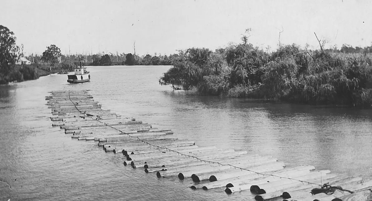
Drogher Aggie towing raft of pine logs, Richmond River. Image courtesy of Richmond River Historical Society.
Rowley Brunker cites one period of four days in which 24 vessels left Ballina carrying 1.7million superfeet of pine and cedar. When most accessible pine was cut out by 1880, the
emphasis switched to hardwoods from the Tabbimoble and Whiporie areas via Bungawalbin Creek.9
As land was cleared and properties fenced, access to Country was impeded with serious consequences for the social, physical and cultural life of Bundjalung people. Some Aboriginal people who had helped clear the land provided seasonal labour on farms and in sawmills. As settlement grew, people were pushed further from town. An Aboriginal Reserve at Box Ridge, set aside under the Aboriginal Protection Board, was gazetted in 1907.
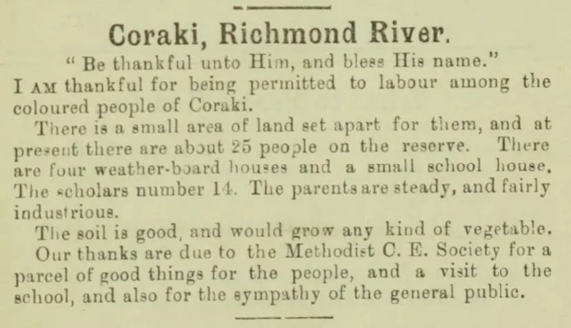
Australian Aborigines Mission, Australian Aborigines’ Advocate, 30 November 1908.
A mission was established there in 1908, when twenty-five people lived in four houses, with a school necessitated by their exclusion from Coraki Public School.
Ruby Langford Gnibi described the cumulative loss of hunting, of ceremonies, of elders, of languages and law, a dispossession woven through the same landscape being cleared and fenced for agricultural expansion.
The Selection Acts from 1862 accelerated clearing, requiring farmers to improve land as a condition of purchase. Trees were felled and burned to meet these conditions. The rich soil and mild climate of the Richmond Valley brought hundreds of settlers to the river. Farmers initially concentrated on maize, then sugar cane, which became the dominant crop on the floodplains, embedding the Coraki district in a globalised trade system.
Between 1866 and 1879 nearly thirty small private mills began operating along the river, though none survived the establishment of the Colonial Sugar Refining Company mill at Broadwater in 1881. Declining prices, drought, disease, frosts and floods destabilised the industry. Dairying came later to Coraki than to other parts of the Northern Rivers but provided an alternative, with a creamery opening in 1896.
As the population of the town increased, so did the pressures on the low-lying, swampy land that surrounded it.14 Insanitary conditions in the 1890s were compounded by Coraki's position on wet ground, and when typhoid fever was reported on the river, the swamps were linked to health risks.
Jo Kijas has described how swamps had long been misunderstood and derided throughout much of European history – feared as contaminated, derided as wastelands. This was in stark contrast to the concepts of bountiful resources and cultural richness that Bundjalung people found in the same places.16 Wetlands are now understood for their role in flood protection, sediment and nutrient retention, and as biological filters improving water quality.
All forms of wetness — rivers, creeks, tributaries, swamps — are connected elements of a single hydrological system. Historic wetlands functioned as water storage, landscape drought-proofing, fire protection and habitat in dry periods.
In times of drought green grass was often limited to the swampy lands.
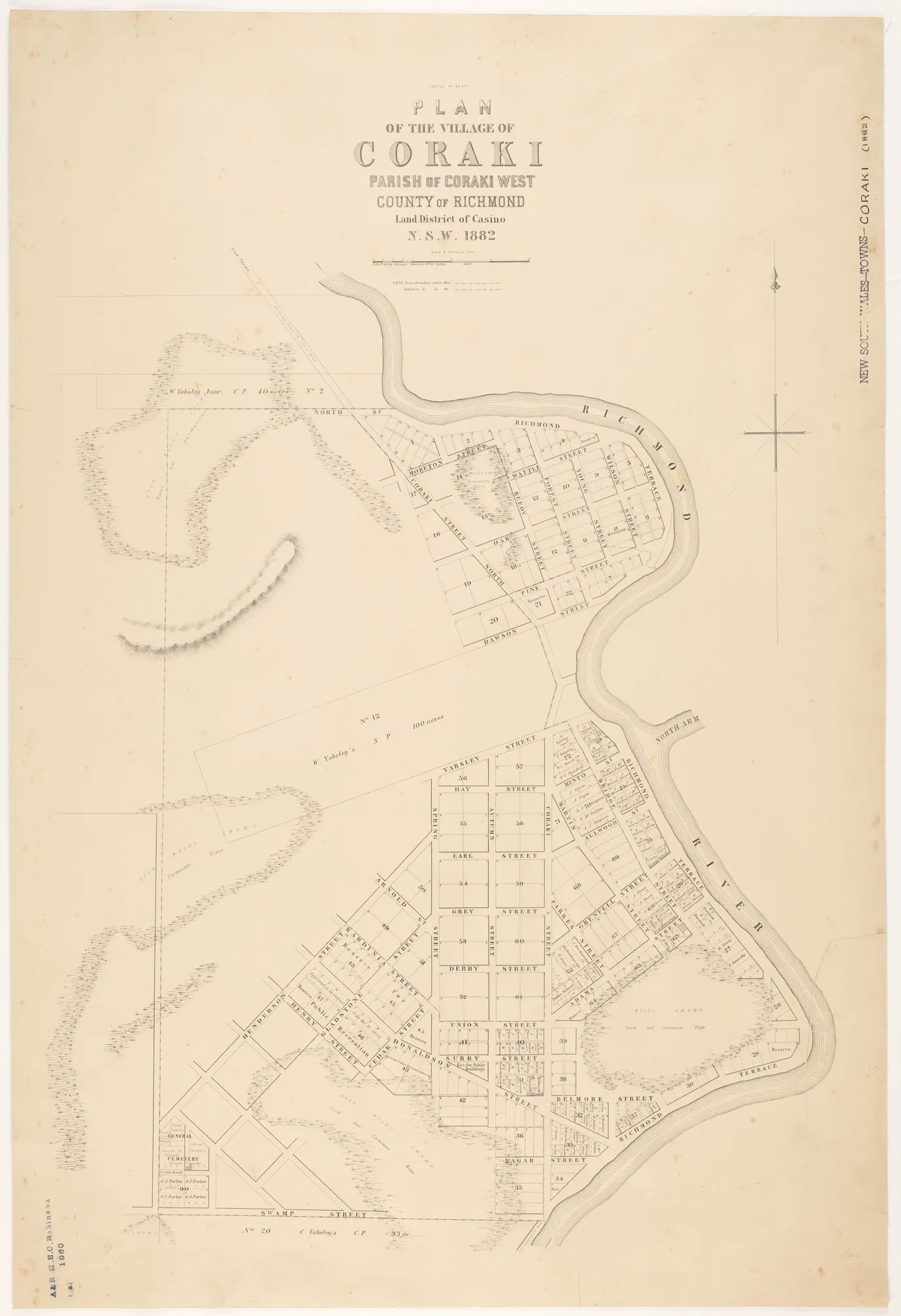
Department of Lands, Surveyor General's Office, Plan of the village of Coraki [cartographic material], 1882. State Library of NSW. Note the identification of swamps.
Drainage works in Coraki were completed in 1908 by the Council, with an outlet to the river. The rationale was fourfold: to make low-lying land available for grazing and residential purposes, to improve the health of the town, and to reduce the impact of heavy rainfall.
Economic arguments were also offered to convert thousands of acres of swamp, considered almost valueless, into productive land. Landholders constructed the first substantial drains in 1887 and drainage unions formed on a voluntary basis in the late 19th century until state funding was introduced through the Water and Drainage Act (1902). The Tuckean Swamp Drainage Trust was formed in 1911 and the main canal completed in 1915, when forty eight homestead blocks were advertised for sale as 'the richest alluvial land in the state.' Draining the swamp produced lasting ecological consequences.
Permanently saturated acid sulphate soils, exposed to the atmosphere, released chemicals into waterways, affecting water quality and combined with blackwater from decomposing organic matter causing fish kills in the worst cases. Eighty-six fish kill events have been recorded in the Richmond River since 1970. In February 2001 the entire estuary downstream of Coraki to Ballina was subject to a massive kill of aquatic life caused by deoxygenation.
Low-oxygen blackwater is generated during flood events when inundation leads to the decay of organic matter, then drained into the estuary as flood waters recede. While fish kills have occurred historically, broad-scale land clearing, floodplain drainage and acid sulphate soil mismanagement have increased their frequency and severity.
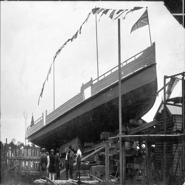
Launch of the Araucaria, Oakland, near Coraki. The Araucaria was built by Oliver Jones and launched in 1917. Photo by George Hunt.
Navigation and environmental transformation
Making rivers navigable and floodplains productive was widely regarded as requiring deliberate intervention – dredging channels, de-snagging, draining and removing invasive plants. Such modifications were driven by participation in global markets and frequently invoked as grounds for state action.
Waterways carried timber, maize, cane and butter from Coraki to coastal ports and metropolitan markets. Dredging commenced in the 1880s for the maintenance of shipping channels. De-snagging – the removal of large woody debris – was pursued from the 1890s as waterway maintenance. The benefits for navigation were clear, but de-snagging also reduces spawning sites, increases water temperatures, diminishes species diversity and accelerates bank and bed erosion.
People in Coraki were keenly aware of the worsening floods and riverbank erosion resulting from the removal of vegetation. Captains of ocean boats complained repeatedly of the shallowing of parts of the river that had previously carried deep water. At the River Bank Erosion Conference in 1908, shire council delegates voted to reduce the speed of ocean going steamers on any portion of the river, taking local action in the absence of what they saw as sufficient government attention.
Water hyacinth, introduced to beautify farm dams, blocked river tributaries and temporarily closed the North Coast Steam Navigation Company. The Coraki Progress Association first wrote to the Harbours and Rivers Department in 1904 regarding the plant in Sandy Creek.
Determining to tackle the problem locally before seeking government funds, a Coraki Water Hyacinth Board was constituted in 1913 through voluntary fees from interested landholders. A boom was constructed across the mouth of the creek and a punt patrolled fortnightly to remove young plants. Of the £300 spent on the work, £100 came from the state government, £50 from Shire funds and £150 from private subscription.32 In 1914 a Water Hyacinth Conference brought district councils together across administrative boundaries to form a board with the power to compel landowners to clear the waters on their property.
The Coraki Show offered a special prize for the best essay on soil erosion in 1938. The winning entry by young Gordon Yabsley argued that erosion was caused by destroying trees and shrubs from the water's edge and that trees should be planted along riverbanks. The Richmond Valley Flood Mitigation Committee later related erosion directly to flooding: unwise land-use practices, by reducing vegetative cover, had lowered rates of infiltration and increased runoff, contributing to higher flood heights. The committee concluded that extensive dredging would be inordinately expensive relative to benefits and that medium and major floods could not be controlled by river channel improvement, levee banks or flood escapes alone.
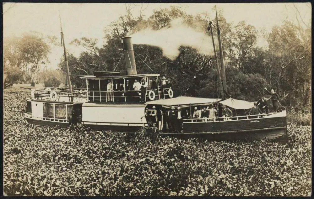
Water hyacinths surrounding drogher Irvington on Richmond River, near Lismore NSW, in 1915. Courtesy of Jim Davidson Australian postcard collection, 1880-1980.
Their argument that forest cover offered far greater protection to soil and reduced surface runoff was repeated in the 1970s by geographer Peter den Exter, who argued that logging in the upper catchment played an important role in flooding problems in the lower valleys and floodplains.
Floods: Adaptation and mitigation
As the population and area of farmed land grew, the impact of weather events intensified. Crops were destroyed, farmers lost stock, and shipping and mail services were seriously disrupted. In a major flood Coraki can be isolated for days. Floodwaters cross the main street from the Richmond River and inundate the south-west of the town fed by the Bungawalbin Creek system, known as the ‘backwater’
Frequent proposals were put forward for draining the lowlying swampy areas around the township of Coraki, often in relation to health concerns. At his own expense William Yabsley constructed hundreds of yards of footpaths made of earth and kerbed with sawn timber, which also formed a drain along some of the main streets.
Drainage works in Coraki were completed in 1908 by the Council, with an outlet to the river. The rationale was fourfold – to make a ‘large area of the lower lying portion of the town available for grazing and residential purposes…to increase the salubrity of the town’, and to reduce the impact of heavy rainfall.
Economic arguments were also offered to convert the ‘thousands of acres of undrained swamps’, considered ‘almost valueless’ into grazing or agricultural land.
The first blocks of land in the Tuckean were sold in the 1870s and ‘80s. Landholders, Henderson and McPherson constructed the first substantial drains in the Swamp in 1887, somereported to be 3.55 foot deep. Drainage unions formed in late 19th century, largely on a voluntary basis, but the Water and Drainage Act (1902) introduced state funding for the first time. Drainage works were often carried out as a vehicle for land development.
The Public Works Department reported in 1902:
'The work of draining the large swamps of the northern coastal districts is progressing, and promise to prove remunerative by converting large areas of speargrass and reeds into first class dairy country.’
Growth in the settlement had accelerated with the introduction of Crown Lands Alienation and Occupation Acts which became effective in 1862. The Acts permitted the conditional purchase of up to 320 acres at a low fixed rate of interest, creating an imperative for clearing the land and ‘improvements’ such as fencing. Trees were felled and often burned by selectors to meet the conditions of their purchase. The rich soil and mild climate of the Richmond Valley brought hundreds of settlers to the river increasing the population to 4000 in 1870, not including First Nations people or sawyers. The Selection Acts were also welcomed by timber workers.
Competition was greatest for the blocks of alluvial land on or near the rivers. The settlers to the Coraki district introduced grazing, sugar cane crops and dairying in the search for a staple crop as timber supplies decreased and agricultural produce was shipped to Sydney. Relationships with the land were shaped by the complex interplay between market demands and what the land could provide.
Farmers initially concentrated on growing maize which thrived in the narrow strips of fertile soil alongside the rivers and grew amongst burnt tree stumps. John Thom, the first Presbyterian Minister in the Richmond based in Coraki, procured sugar cane in the 1860s and distributed it to farmers. On news of his death a Casino correspondent recalled ‘how earnestly and feelingly he spoke of his sympathy with the selectors round about him, and how well he “ken’d” the hard struggle many of them had to live’. 35 Sugar cane became the dominant crop in the floodplains of the Richmond River embedding the Coraki district in a globalized trade system.
Between 1866 and 1879 nearly thirty small private mills began operating along the river’s edge, although none survived the establishment of the Colonial Sugar Refining Company mill in Broadwater in 1881. Cane farming was generally a small enterprise on family farms with an influx of people to the district coming at the beginning of the cane cutting season. Declining prices, drought and disease impacted the industry at the end of the century, as well as labour costs, transport, frosts and floods. Donald MacKinnon who ran a sugar mill with his brothers at Oakfield in East Coraki wrote in his diary in 1892 of preparing to get sugar ready to send to Sydney.
'It is, I hope, the last sugar we will ever send away from this place. Sugar has ruined many here and in Queensland. We have been manufacturing it for 20 years, and it has cost us well over GBP3000, and with interest at 8 per cent. The proposition is hopeless.'
Donald MacKinnon
MacKinnon lost eight acres of pumpkins and potatoes in the flood the month before and his cattle were starving with little or no grass. Dairying came to Coraki much later than other parts of the Northern Rivers but provided an alternative option. A creamery opened in 1896 to much celebration and promise of prosperity, with intending suppliers from Swan Bay, Bungawalbin and the North and South Arms of the Richmond.38 The River remained the most important transport route for cream boats and seagoing ships navigating inland.
As land was cleared and properties fenced, access to Country was impeded with flow on impacts on the social, physical health and wellbeing of Bandjalang people and the land. Some Aboriginal people who had helped clear the land provided seasonal labour on farms, and sawmills were also a source of stable employment.
As the settlement grew people were pushed further out of town and an Aboriginal Reserve Box Ridge, set aside under the Aboriginal Protection Board, was gazetted in 1907. Bandjalang people continued to hunt and to access food from Country, crucial in supplementing the meagre quantity and poor quality of rations, but access was severely diminished over time, as Ruby Langford Gnibi describes:
'No more warriors hunt and bring home nunghing, so that our family clans can eat! Gone are all our tribal ways, only three elders left; all old dubays. No old Nugthungs to tell our stories and legends, or give us our laws! No more corroborees, no more singin’, no more clap sticks, no morebull roarer tellin’ of initiation, no more diggin’ for yams with yam sticks. Only broken down homes with pain peelin’ and fences fallin’ down and cars to go to town on pension days to shop.'
Bandjalang people had lived and worked in close proximity to early settlers, whose survival had depended in the early days on their good will, cooperation and labour.
Navigation and environmental transformation
Frustration in the town with the colonial government 800 kilometres away intensified through the 1890s, fuelling demands for municipal self government, but the local economy was also tied to Sydney by the shipping trade.
Farmers were firmly embedded in a global capitalist market, but the viability of their agricultural pursuits depended as much on local environmental conditions as on external markets. Waterways carried timber, maize, cane and butter from Coraki to coastal ports, to metropolitan markets in Sydney or overseas.
Making rivers navigable and floodplains productive was widely regarded as requiring deliberate intervention – drainage works, dredging channels, desnagging, and removing invasive plants. Such environmental modifications were driven by participation in global markets, frequently invoked as grounds for state intervention.
The river provided impetus for councils to sometimes work across the administrative structures that impeded a catchmentwide approach. The infestation of water hyacinth, introduced to beautify farm dams, blocked river tributaries and temporarily closed the North Coast Steam Navigation Company. The Coraki Progress Association first wroteto the Harbours and Rivers Department in 1904 regarding water hyacinth in Sandy Creek.
At the River Bank Erosion Conference in 1908 at Wardell shire council delegates voted to reduce the speed of oceangoing steamers on any portion of the river, taking local action in the absence of what they perceived as sufficient government attention.
In response to ongoing complaints, the Department of Public Works explained in 1911:
There are no less than five dredges at work, and the object was to give a depth of 14ft. at low water from Ballina to Coraki, 12ft. from Coraki to Lismore, and 8ft. from Coraki to Lismore. There was no river on the coast where such a systematic and sustained effort had been made to obtain trade facilities… Under these conditions Richmond Riverites have not much to complain of.
The Coraki Show offered a special prize for the best essay on soil erosion in 1938, confirming the subject remained a source of serious consideration. In his winning essay Master Gordon Yabsley explained that erosion was ‘caused by destroying trees and shrubs from the water’s edge and thus removing the means of binding the soil together’, and argued that ‘Trees should be planted along river banks.’
Under an early piece of environmental legislation, the Soil Conservation Act 1938, the Soil Conservation Service of New South Wales was formed in 1938, invested in retaining soil and improving soil quality.
Twenty years later, the Report of the Richmond Valley Flood Mitigation Committee related the issue of erosion to flooding.
Unwise landuse practices by reducing vegetative cover to a condition whereby it provides inadequate protection of the soil has caused soil erosion in many parts of the Richmond River catchment… By reducing ground cover these practices lower the rate of infiltration of water into the soil and increase runoff, thereby contributing to increases in flood heights… The general application of recommended soil conservation and catchment protection practices could have an appreciable influence on runoff and the incidence of stream flow during minor flood rains.
The committee concluded that ‘extensive dredging of the river channel would be inordinately high in relation to benefits’ and medium and major floods, ‘cannot be controlled by river channel improvement, diversions, levee banks or flood escapes.’
Their argument that forest cover offered far greater protection to soil and reducing surface runoff, was repeated in Peter den Exter’s advocacy to protect remaining forests in the 1970s. The lecturer in geography at Northern Rivers College of Advanced Education argued not only that logging was a factor in flooding, but that vegetation in the upper catchment plays an important role in flooding problems of the lower valleys and floodplains.
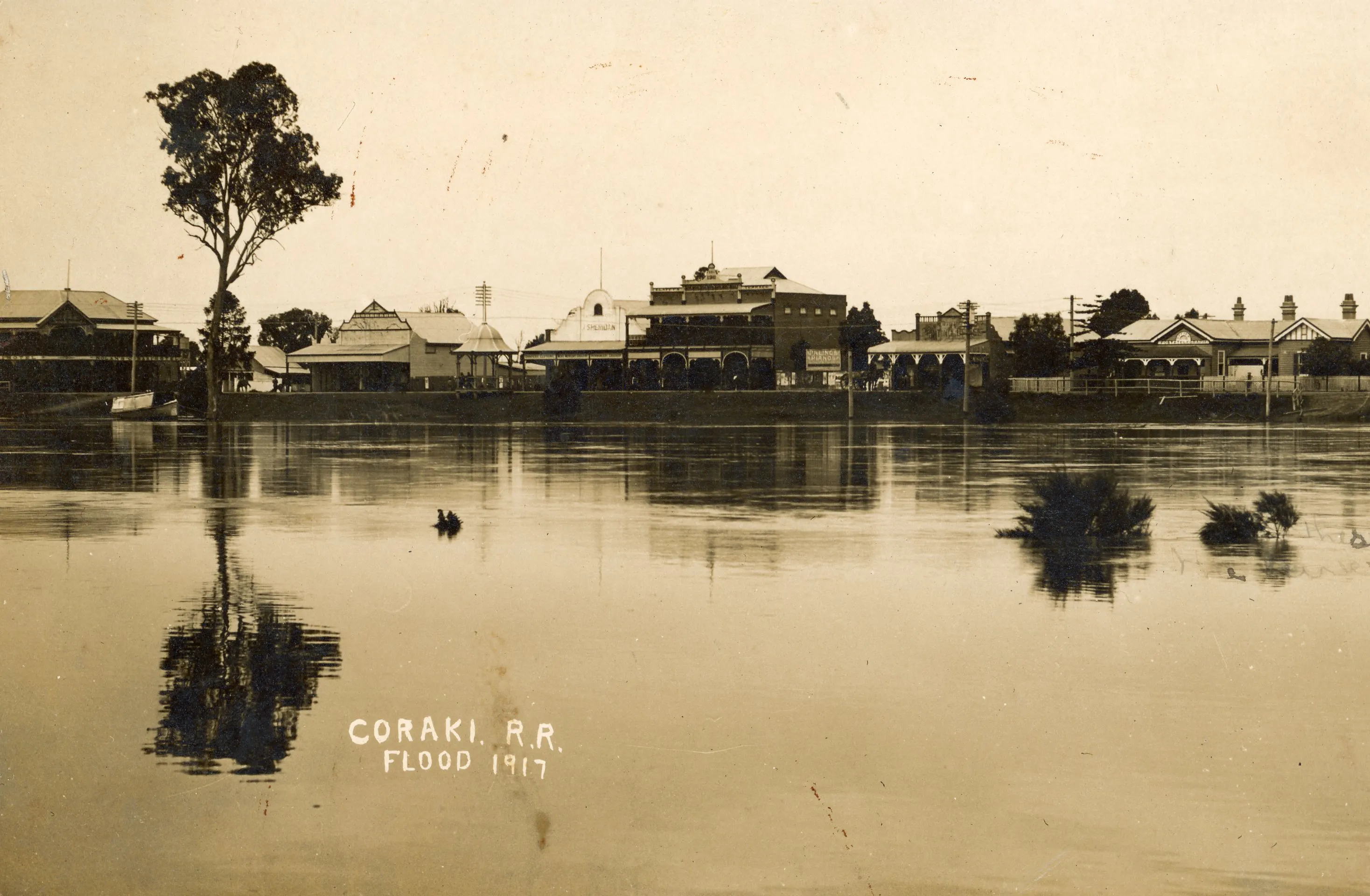
As the population and area of farmed land grew the impact of weather events increased. Crops were destroyed, farmers lost stock, there were serious stoppages to shipping and mail services. In a major flood event, Coraki can be isolated for days. Floodwaters cross the main street from the Richmond River and inundate the southwest of the town fed by the Bungawalbin Creek system, known as the ‘backwater’.
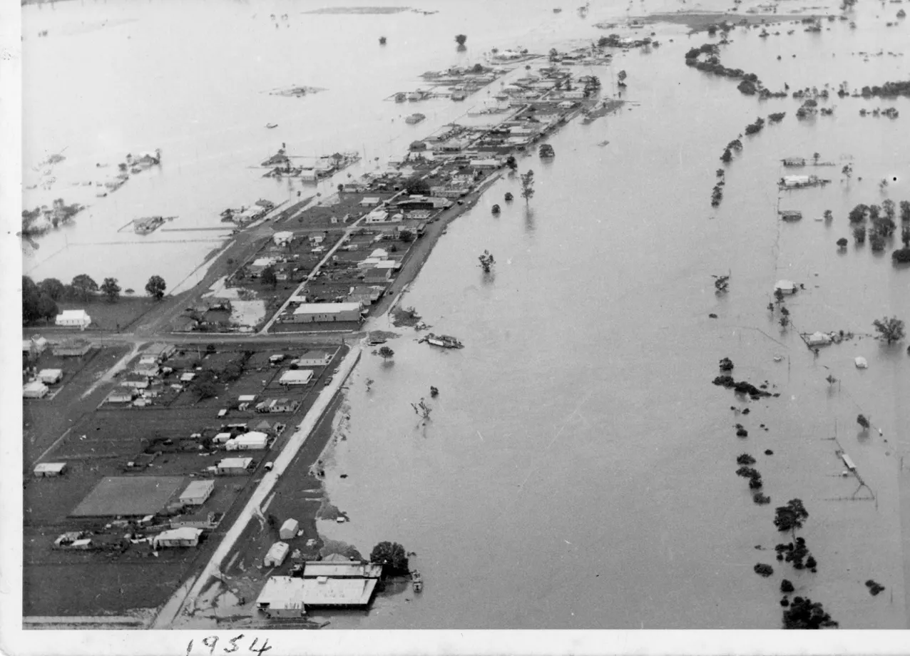
This photograph from the 1954 flood graphically illustrates the way Coraki is cut off on both sides of the town. Photograph courtesy of Mid Richmond Historical Society.
A major flood was recalled in 1857, but no records were kept of the heights.
Fortynine major floods of 5.7 metres or more as measured by the Coraki gauge have been recorded between 1870 and 2022. In a single year multiple flood events may occur. In 1893 there were three major floods (January 5.79m, February 6.93m, March 5.79m), five altogether that year and on the back of a flood the year before that had forced some farmers off the land.
Coraki didn’t have a local police magistrate through which aid could be distributed in times of emergency, but the mayor campaigned local members and received ℑ100 spent employing people on roadworks.
Successive floods throughout the 1890s galvanised residents to campaign for a flood mitigation scheme that would allow flood waters to escape more rapidly, which became a major issue in New South Wales Parliament towards the end of the century. The proposal for a Tuckean flood escape scheme to Broadwater was defeated, but a report in March 1893 by the Water Conservation Branch for a flood relief channel from Tuckombil Creek to Evans River favoured the project on the proviso that locals help finance it.
Even after another flood in July that year, the government were still unable to pay for the scheme.


Drought largely dominated the first part of the 20th century, with the first major flood in 1921, another ten years later in 1931, and then the return of successive major flooding through from 1945 to 1967.
During the period in which dryer conditions had prevailed substantial development had taken place in the town and on most of the floodplain. Drainage channels taking floodwaters off agricultural land and into the river combined with erosion from cleared lands caused large quantities of sediment to smother habitats in the river system.
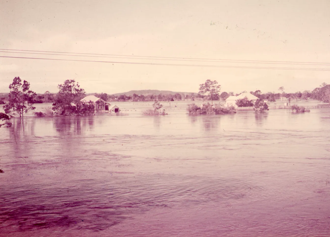
1965 flood in Coraki. Image courtesy of Mid Richmond Historical Society.
The Tuckean Swamp Drainage Trust was formed in 1911 and the main canal completed in 1915 when 48 homestead blocks were advertised for sale, claiming it to be ‘the richest alluvial land in the state.’62 In periods of drought it was used for grazing, being described in 1936 as ‘alive with cattle’ from the Clarence and Upper Richmond.
Draining the swamp resulted in permanently saturated Acid Sulphate Soils being exposed to the atmosphere. Rains cause these chemicals to be washed into waterways effecting water quality, and in the worst cases, fish kills. Deep drainage channels and oneway floodgates increases acid sulphate oxidation. A combination of acid sulphate discharges and blackwater from decomposing organic matter is responsible for fish kill events.
86 fish kill events have been recorded in the Richmond River since 1970.
In February 2001 the entire estuary downstream of Coraki to Ballina was subject to a massive kill of aquatic life due to deoxygenation. Low oxygen blackwater is often generated during flood events when inundation leads to the decay of organic matter then drained into the estuary as flood waters recede.
While fish kills have occurred historically the significant impact of broad scale land clearing, the establishment of nonwater tolerant vegetation in low lying areas, floodplain drainage and regulation on floodplain wetlands, acid sulphate soils management and water quality issues are all recognised as increasing their frequency and severity.


Major flooding from the 1940s put flood mitigation back on the agenda. A large flood in June 1945 was followed by 14 more floods to May 1956, including the February 1954 flood, the worst on record to that point.
Following the 1954 floods the Richmond Valley Flood Mitigation Committee was established and delivered its final report in 1958. The Richmond River County Council (predecessor of Rous), was formed covering the City of Lismore, and the Shires of Gundarimba, Tintenbar and Woodburn (in which Coraki was situated), as a state sponsored flood mitigation scheme for the catchment.
Major works constructed in the period around Coraki included widening and deepening the Tuckombil Canal, clearing melaleuca swamps, the establishment of a levee at Bungawalbin, a drain from Bora Ridge to Bungawalbin Creek with headworks and floodgates installed and drains and floodgates at West Coraki.
As part of the works on Tuckombil Canal an inflatable fabridam was installed to prevent the passage of saline waters from Evans River into Rocky Mouth Creek and the Richmond River. The fabridam could be deflated during floods to allow for the passage of flood waters but saltwater intrusion required a closed canal, which was often unreliable.
Tuckombil Canal increases the volume of freshwater discharged from the Richmond into the Evans River, increasing peak flood discharges and changing the freshwater flow and geomorphology of the Evans River which impacts on aquatic and terrestrial flora and fauna. Amanda ReicheltBrushett et al. have pointed to the changes in the ecosystem, bank erosion and weed infestation that accompanied clearing the vegetation for agriculture and higher salinity caused by the Tuckombil Canal.69 A barrage was completed at Bagotville on the estuarine Tuckean Swamp in 1971, limiting salt water intrusion the 1915 drainage system had enabled. As Jo Kijas explains:
'combined with new flood mitigation works of the late 1960s, this closure provides a clear marker of further dramatic environmental change in the Tuckean Swamp. Not least, the fish nursery within the blended waters of the Swamp around the head of the Tuckean Broadwater was now closed off to the Richmond River.'
By 2022, existing flood mitigation infrastructure across the floodplain included 111 drainage canals, 772 flood control structures, 64 levees, 6 pump stations and the Tuckombil Canal.
Changes in land use accompanied flood mitigation and drainage, making agriculture economical in lowlying floodplains. Inevitably these farms also suffered from flood, drought, and in many years losses from frosts. Donald MacKinnon’s diary from 1895 is hopeful that ‘Our maize should do well this season’, but one month later after a series ofthree months of frosts and drought, laments ‘Our maize is done for. ’
When the floodgates at Sandy Creek were carried away in the 1931 flood their reconstruction was demanded as quickly as possible; ‘Land in this locality,’ it was observed, ‘is too valuable to be allowed to suffer as the result of adverse seasonal conditions.’
The increasing intensity and frequency of climate related disasters also expose more people to greater risks.
The 1921 flood was the first serious flood event on the Richmond for 28 years. The Richmond River Herald declared that it had provided a series of lessons for the district, most importantly,
‘it has disposed of the fallacy, hitherto fairly widely entertained, that big floods would never occur again.’
Denudation of the timber belts, clearing of the land, effective drainage, and the existence of the Tuckombil flood escape may all tend to provide facilities for a more rapid getaway for flood waters, but, so far as the Mid Richmond at any rate is concerned, all these count for nothing, or very little when the vast watershed of the river sends down its torrents, contemporaneously with a high sea, and swamps filled to the brim. With such adverse conditions, not only are we likely to see just as big floods as any of the past, but possibly even bigger ones.
Response and recovery
Damage from floods were often devastating, but it was also felt that consequences could be worse without the volunteer efforts of locals.
Calls for a properly equipped water brigade or provision of a rescue boat for the police were made repeatedly. In 1893, the newspaper complained ‘at almost every town with the exception of Coraki the police are provided with a boat for the purpose of rescue work in times of flood.’
‘It is a monstrous state of affairs’, the editor wrote in 1921, ‘that the rescuing and provision of those out from the town should be left practically to chance.’
Ten years later in receipt of a letter from the Chief Secretary’s Department declining to provide flood relief boats for district centres, one Coraki councillor moved that they request the provision of a suitable flood boat for police. The motion was carried, but not without debate. ‘The police don’t want the job,’ one councillor objected. ‘Flood boats, judging by past experiences, seem to be everybody’s business and end up being nobody’s.’
At one time, it was felt, a ‘fleet of “flatties” used to be in evidence on the water front, but today the number of safe craft is restricted to the ferry boat, and one or two small punts.’
As regional road infrastructure expanded private river transport would have been in decline. The ferry boat was frequently used for emergency crossings until the Department of Main Roads discontinued its use in 1953. Coraki fisherman Len Gallagher continued to operate his own boat, sometimes against union protests. He brought supplies and medical help to people and when flood waters entered their homes took them to safety.
The question of a Water Brigade and Fire Brigade occupied Council discussions throughout the first part of the 20th century. In the wake of the fire that destroyed the Club Hotel in 1897, the Richmond River Herald urged for the formation of a fire brigade for ‘checking of the firefiend when he is turned loose’ in Coraki and pointed out the inefficacy of ‘undisciplined bands of workers.’
A series of disastrous fires claimed many buildings in Richmond Terrace, many with residences attached. In 1905 some 800900 people gathered to fight the fire in the main street and save belongings. The Richmond River Herald reported that the main business block was almost completely wiped out of existence by another huge fire in 1911. Cordons of men sent bucket after bucket up ladders and across rooves and on to boys to refill the empties. When it wasall over residents provided for those who had suffered, clothing was loaned, accommodation provided where needed ‘hospitality was extended to all, and there were scores of various offers of assistance from kindlydisposed fellow townspeople.’
The Mayor was prompted to call a meeting to request the Fire Board declare Coraki a fire district. The Fire Commission had removed Coraki from the operation of the Fire Brigades Act because it refused to meet the financial requirements that disqualified it from any assistance or direction.
The community voted against establishing a fire brigade in a referendum in 1913 due to the financial burden. It remained a local matter, with bucket brigades performing their best. The Council’s request for Coraki to be included in the Act for the purpose of establishing a fire brigade was approved in 1920 and a volunteer brigade commenced in January 1921.
The proximity of State Forest, State Conservation Area and National Parks in the Valley exposes Coraki to bushfire hazard. In the past, forest reserves and state forests posed a similar threat. The Forestry Commission campaigned for regulations for the prevention of fire, but thought them no use ‘unless the public generally and individuals especially realise the dangers and cooperate in obviating them as much as in meeting them when they materialise.’
The State Emergency Service was established in 1955 as the Civil Defence Service, emerging from the need for a coordinated response to devastating floods of the 1950s in New South Wales.85 In the early years people continued the practice of using their own personal vehicles and boats for emergency response. It continues as a volunteerbased organisation.
Every flood is different, but SES Flood Information from the Coraki Gauge illustrates the expected consequences of different flood heights and road closures. At the junction of the Richmond and Wilsons Rivers, Coraki can bear the brunt of both systems and the town is cut off with the backwater filling lowlying areas and isolating residents on islands. In 2022 Coraki was marooned for five days by floodwaters with residents fending for themselves.
Preparing for and managing adverse events, like floods and bushfires has become a priority for councils and emergency services like the SES. How communities prepare is often related to the development of resilience, seen as important in disaster response and recovery.87 While a preventionpreparednessresponserecovery (PPRR) framework designed to prevent disasters and mitigate potential impacts is more common for floods, drought management is still largely dominated by a crisis management framework.88 Responses to flooding in the Northern Rivers have tended to focus on flood prevention, with the use of structural solutions, like levees and flood gates over other mechanisms, such as land use planning. Building community leadership capability, community resilience and the capacity to adapt and cope with the impact of adverse effects is the aim of the Richmond Valley Community Preparedness & Resilience Plan, highlighting community awareness as a risk management strategy.89 The plan was prepared in the context of the 2019 bushfires that resulted in 48.6% of the local government area being impacted by fire, following on from a long period of drought. It does not include preventative measures like water conservation. Droughts, like floods are part of a natural cycle, but crisis management and relief are generally emphasised over prevention and mitigation. Given the understanding locals haveexpressed in the past, about the role of forests, the effects of landuse and the inefficacy of mitigation efforts, more attention could be paid to the larger forces creating disasters. The treatment of land and nature as a resource, has not served Country or community well.
Conclusion
An environmental history of Coraki reveals the local knowledge the community has about its own environment and their relationship to it. While floods, droughts and fires naturally occur, Coraki is not isolated from the rest of the region and over time became more integrated into a world system.
Flood behaviour is influenced by where the rain falls and which tributary the water comes down, the location of structures (levees, embankments for roads and railway lines, floodgates, canals, barrages) and land use, often tied to markets somewhere else. Three major inflows, of the Richmond River, Wilsons and Bungawalbin Creek (significant catchments in their own right), can affect Coraki.
The traditional reliance of the township on timber, shipping and agriculture also extends the geographical boundaries of places of significance. Weather and climate related hazards, drought, fires and floods impacting farmers were felt in the township because it’s ‘economic fate was tied to theirs.’
Drainage, deforestation, erosion, mitigation and the factors that produced them altered water flow, sediment loads and ecosystem health before the river reached the town and carried these tribulations to the river mouth. The environmental consequences and lived experience of these transformations were felt most immediately within the local community.
Residents organised themselves alongside persistent calls for greater government responsibility. While fragmented governance structures, divided between local, state and Commonwealth jurisdictions, could impede effective action and diffuse responsibility, collective action was initiated on the ground.
Economic interests were sometimes favoured over longterm ecological sustainability, but whether it was locals digging their own drains, removing water hyacinth, or planting trees, they were intricately connected to the environment, shaping the landscape in ways that would resonate into the future.